
Oileain Arann. A Map of the Aran Islands, Co. Galway.
Roundstone, Co. Galway, Folding Landscapes, 1996. 91 x 50 cm (unfolded). As new.
EUR 200,-- Order
The catalog contains 39 items. Drop search results and show the complete catalog.
Order by: Author · Title · Keyword · Year · Price (up) · Price (down) · Inventory Number · Recent Changes · Relevance
La Saone de Lyon A Corre. (Jonction au Canal de l’Est). Carte Pour La Navigation. Echelle: 1/20000 e.
2nd Edition. Lyon, Rene Salagnac, 1958. 20 x 29 cm (oblong). 21 Folding Plates (Feuillet). Original stiff cardboard covers. Stapled. Title on front board and spine. Very good condition. Minor shelf wear and dust dulling. Internally bright and clean.
EUR 40,-- Order
Smith’s Classical Atlas & New General Atlas (two Atlases bound into one). Full Titles: 1. Smith’s Classical Atlas Containing Distinct Maps of the Countries described in Ancient History both Sacred and Profane / 2. Smith’s New General Atlas Containing Distinct Maps of all the Principal Empires, Kingdoms, & States Throughout the World. Arranged According to the General Treaty signed in Congress at Vienna, June 1815.
London, Printed for C. Smith, Mapseller extraordinary to his Majesty, 1820 & 1822. c. 40 x 32 cm. Classical Atlas: Engraved title page, TOC, 14 Maps, incl. eight double paged / 2. Engraved title page, TOC, 49 Maps, incl. 7 doubled paged. Complete with all maps, as listed in the TOCs. Contemporary half leather over marbled paper boards. Rebacked in 2024 using the original boards and spine. New end papers. Very good condition. Binding rubbed and bumped with minor material losses to spine ends and corners. Ages age darkened. Internally clean with mild dust dulling and occasional very mild foxing. Some neat annotations to some maps, mainly Britain and Europe. Overall a very nice copy of two atlases, published in 1820 and 1822, bound into one.
EUR 2.000,-- Order
Memoirs of the Geological Survey. Explanatory Memoir to accompany Sheet 75 of the Maps of the Geological Survey of Ireland, illustrating a Portion of the County of Mayo.
Dublin, Alexander Thom, 1872. 24 x 15 cm. 37 pages. With a few illustrations in B&W. Original brown paper wrappers. Very good condition.
EUR 30,-- Order
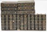
An Universal History, from the earliest Account of Time to the Present. Compiled from Original Authors; and Illustrated with Maps, Cuts, Notes, Chronological and other Tables.
Volumes 2 to 19 (18 Volumes in Total). Dublin, Printed by Edward Bate, for the Editors, 1744 / 1745 / 1746. 19.5 x 12.5 cm. Vol.2: (2), 630 pages / Vol.3: (2), 645 pages / Vol.4: (2), 629 pages / Vol.5: (4), 615 pages / Vol.6: (2), 636 pages / Vol.7: (2), 653 pages / Vol.8: (2). 638 pages / Vol.9: (4), 651 pages / Vol.10: (2), 656 pages / Vol.11: (2), 632 pages / Vol.12: (2), 646 pages / Vol.13: (2). 650 pages / Vol.14: (2), 666 pages / Vol.15: (2), 724 pages / Vol.16: (2), 749 pages / Vol.17: (2), 813 pages / Vol. 18: (2), 706 pages / Vol.19: (2), 760 pages plus 10 pages Index. For list of Plates per volume, please see comments. Contemporary uniform calf. Spine label with title in gilt. Gilt decorations on spine. Raised bands. Red speckled edges. All volumes in very good condition, except for Vol. 5, which is seriously damaged by bookworm. All volumes rubbed and bumped. Age darkened edges and end papers. Very few annotations. Top edge of volume 19 marked with red felt pen. Internally age darkened with the occasional closed tear. Some plates with closed tears and poor folding. Overall a very nice and interesting set with some amazing Plates and Maps.
EUR 1.650,-- Order

The Imperial Gazetteer of Scotland; or Dictionary of Scottish Topography. Compiled from the most recent Authorities. And forming a complete Body of Scottish Geography. Physical, Statistical, and Historical. Illustrated with a complete County Atlas, various chorographical Maps, Plans of Ports, Harbours, and interesting Views.
Two Volumes – Complete. London and Edinburgh, A. Fullarton & Co., ND (c. 1860). 25 x 16.5 cm. Vol.1: lxviii, 816 pages / Vol.2: 872 pages. Both volumes with coloured maps, and B&W plates. Volume 1 with a large folding map of Scotland (repaired in the back). Contemporary half calf over cloth covered boards. Marbled edges. Gilt and blind decorations. Spine labels. Very good condition. Binding rubbed and bumped. Edges and end papers dust dulled. folding map with long closed tear, which has been repaired in the back. Internally bright and clean. A very nice copy with interesting Maps and Plates. See images.
EUR 260,-- Order