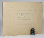
La Saone / Le Rhone.
Two Volumes. Lyon, Rene Salagnac, 1958 & 1960. 29 x 20 cm (oblong). 21 and 15 folding Plates. Original stiff cardboard covers. Stapled. Very good condition.
EUR 70,-- Order
The catalog contains 44 items. Drop search results and show the complete catalog.
Order by: Author · Title · Keyword · Year · Price (up) · Price (down) · Inventory Number · Recent Changes · Relevance
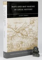
Maps and Map-Making in Local History. Maynooth Research Guides for Irish Local History Number 7.
First Edition. Dublin, Four Courts Press, 2004. 23 x 15 cm. 344 pages. With many B&W map illustrations. Original black cloth with silver title on spine. In original decorated dust jacket, now inside archival jacket. Very good in very good dust jacket. Minor shelf wear. Edges dust dulled. Nice copy. See images.
EUR 75,-- Order
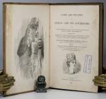
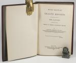
Lares and Penates: or Cilicia and its Governors. Being a short historical Account of that Province from the earliest Times to the Present Day.
First Edition. London, Ingram, Cooke and Co., 1853. 22 x 14 cm. xiv, 394 pages plus two pages publishers list. Original cloth with blind and gilt decorations. Later professionally rebacked using the original boards and spine. New end papers. Very good condition. Binding rubbed, bumped, age darkened and stained. Edges age darkened. New end papers. Single stamp (Franciscan Church Waterford) on title page. Closed tear to folding map (see image). Internally clean, no annotations etc.
EUR 75,-- Order
A Voyage to Abyssinia and Travels into the Interior of that Country. Executed under the Orders of the British Government in the Years 1809 and 1810.
New Impression. Facsimile. London, Frank Cass & Co., 1967. 24 x 18 cm. ix, (6), 506 pages, lxxv. Complete with all Plates and Maps, as listed. Original red cloth. Hard cover. Gilt decorations and title on black spine label. In a clear plastic wrapper. Very good condition. Ex Library with one library stamp on title page and another one on the top edge of the book. Small number sticker on spine and another one on title page. Brown glue stains to end papers. Internally a bright and clean copy with no further stamps or markings.
EUR 125,-- Order
Rocky Mountain Health Resorts. An Analytical Study of High Altitudes in relation to the Arrest of Chronic Pulmonary Disease.
First Edition. Boston, Houghton, Osgood and Company, 1880. 20 x 14 cm. xii, 192 pages plus 18 pages of advertisement. Includes a large colour fold-out map and a large folded ‘Chest Examination Chart’ in a pocket. Dark red cloth with gilt title on spine. Hard cover. Grey end papers. Very good condition. Minor rubbing and bumping to boards, corners and spine. Spine ends frayed. Very small stain on front board. Small bookseller stamp on front paste down. Closed tear on fold-out map (not affecting the map).
EUR 150,-- Order
Atlas Portatif et Itineraire de L’Europe. Pour Servir D’Intelligence Au Guide des Voyageurs Dans Cette Partie Du Monde; Compose de Treize Cartes et Vues.
Huitième Edition. Paris, Chez Hyacinthe Langlois, Libraire – Geographe, 1817. 22 x 15 cm. Half title, title page, followed by 10 (of 13) folding Maps. See list below. Full vellum. New spine label. Good condition. Lacking two of the alpine panoramas and the map of Italy. Remaining maps in good to very good condition. Some dust dulling, edgewear and mild staining.
EUR 150,-- Order
The New Practical Navigator; Being A Complete Epitome of Navigation: To which is added, all the Tables Requisite for Determining the Latitude and Longitude at Sea…
The Seventeenth Edition. Greatly Enlarged and Improved. London, Printed for Johnson, Richardson et al, 1807. 21 x 13 cm. xvi, 328 pages plus Tables. With a Frontispiece and ten Plates. New (2021) dark blue half cloth over matching marbled boards. New end papers. Gilt title and decorations. Internally age darkened and mildly foxed in places. Edges age darkened. Some of the plates with some paper losses to front edge, but not affecting actual images.
EUR 195,-- Order